Orbits
How does a satellite stay over the same place on Earth? The ground is turning, so the satellite has to go around with it. For a geostationary satellite, that means travelling at about three kilometres a second. From down here, we'd see it in the same part of the sky the whole time.
The satellite is falling towards Earth as it goes. It has enough sideways speed that the ground curves away beneath it, and it keeps missing the surface. Gravity continually bends its path, and with the right sideways speed for its height, that path forms a circle.1
I've put three circular orbits on the same clock below. All three go east, directly above the equator, and we're looking down from the north. Each dashed spoke turns with Earth, so we can follow a satellite against the ground beneath it. The circles fill their panels; Earth's shrinking size shows how much farther out each orbit is.
Three circular orbits on one clock
Low Earth orbit
400 km up
92.6 min per orbit
Medium Earth orbit
20,200 km up
11.98 h per orbit
Geostationary
35,786 km up
23.93 h per orbit
The low satellite gets around in about 93 minutes, repeatedly overtaking its spoke. At 20,200 kilometres up, the middle satellite takes nearly twelve hours. The geostationary one takes almost a day, staying on its spoke as both turn together.
Why does the higher one take so much longer? Its circle is bigger, for one. But gravity also weakens farther from Earth's centre, and the speed needed to stay in a circular orbit is lower. It has farther to go and goes more slowly.
At about 35,786 kilometres above the surface, a lap takes 23 hours, 56 minutes. This matches Earth's rotation relative to distant stars, called a sidereal day. The familiar 24-hour day includes a little extra turning: Earth has moved along its orbit around the Sun, so it has to turn slightly farther to face the Sun again.2 For keeping pace with the ground, we need a slightly shorter day.
Keeping up with the ground
So we've found the height for a day-long circular orbit. We can tilt that circle and still complete it in the same time, though the satellite will now spend half the orbit north of the equator and half south. What would that look like from the ground?
Follow the point directly beneath the satellite and draw its path across latitude and longitude. This is its ground track. Below, the first satellite stays over one point. The second follows our tilted circle. For the third, I've kept the orbit above the equator but made it elliptical. Its longest diameter is the same as the circle's diameter, which keeps the lap time at one sidereal day.1
Three equal periods, only one fixed point
Circular, equatorial
Tilted 30 degrees
Elliptical, equatorial
The tilted circle draws a figure-eight. At an equator crossing, some of the satellite's motion goes north or south, so its eastward progress in longitude is slower than Earth's turn. At its northern and southern limits, it's travelling entirely east, across more closely spaced lines of longitude, and gets ahead of the ground. Its speed around the circle hasn't changed. This east-west wandering, combined with the north-south motion, makes the loops.
The ellipse produces the line on the right. This satellite moves faster when it's closer to Earth and slower when it's farther away. The ground keeps turning steadily, so the point beneath it travels east and west along the equator. It returns after a day, but it hasn't spent that day above the same place.
All three are geosynchronous: their orbital periods match Earth's rotation. Only the first is geostationary. To keep it over one place, we need the whole combination: a day-long orbit that's circular, above the equator, and going in the direction Earth turns.3 NOAA's GOES weather satellites use this arrangement to keep watching the same region. Forecasters can follow a storm through successive images as its clouds build and move, without waiting for the satellite to come around again.4
Getting farther north
That tilt we just introduced is useful when we want to pass over places away from the equator. We measure it from the plane of the equator and call the angle inclination. An untilted orbit has an inclination of zero; tip it all the way upright to 90 degrees and its path goes through both poles.
The International Space Station's orbit is tilted by 51.6 degrees.5 GPS satellites are much higher, at roughly 20,200 kilometres, with a nominal tilt of 55 degrees.67 I've used those inclinations for the first two paths here, then added a polar orbit and a near-polar one. Each map follows a satellite for one sidereal day.
In the first map, follow the solid line and then the dashed one. Those are successive laps. While the satellite completes a lap, Earth turns beneath it, bringing different ground into its path. This is how a satellite can keep circling in one orbital plane and pass over different parts of the world.
Inclination controls the latitude a ground track can reach
ISS-like
400 km; inclination 51.6 degrees
GPS-like
20,200 km; inclination 55 degrees
Exactly polar
705 km; inclination 90 degrees
Near-polar, sun-synchronous
705 km; inclination 98.2 degrees
The first path reaches 51.6 degrees north and south before turning back. The GPS-like path reaches 55 degrees, despite being much higher. For the point directly beneath either satellite, the tilt sets how far north or south it gets.
The last map has an inclination of 98.2 degrees, which might look strange when latitude only goes up to 90. Inclination also tells us which way the satellite travels. Past 90 degrees, it goes against Earth's rotation, in a retrograde orbit. Its latitude limit is then 180 minus the inclination: 81.8 degrees north and south in this case.
A satellite doesn't have to be directly overhead to be useful. GPS receivers use signals from several satellites spread across the sky; the constellation has several orbital planes to make that possible.6 A camera can also look to the side of its ground track. The lines tell us where the satellites pass, and the instruments determine what they can do from there.
Coming back in the same light
Suppose we're comparing pictures of a forest taken months apart. A morning picture and a late-afternoon picture would give us different shadows even if nothing in the forest had changed. We'd want the satellite to visit at a similar local time.
As Earth travels around the Sun, an orbit whose plane stays fixed relative to distant stars ends up facing the sunlight differently. Its equator-crossing time drifts through the day. To keep each southward crossing at roughly the same local solar time, the plane needs to turn once a year along with Earth's journey.
A sun-synchronous orbit does this by making use of Earth's slightly flattened shape. The extra mass around the equator makes the orbital plane gradually turn, a motion called precession. With the right combination of height and tilt, that turn matches the yearly one we need.8
Turning the orbit with the year
The plane keeps its direction
The plane turns with the year
Landsat 8 uses such an orbit. It circles Earth in about 99 minutes and crosses the equator southward at around 10:12 a.m. local time. Its camera takes in a strip 185 kilometres wide on each pass. Earth has turned between passes, bringing a different strip beneath it; the ground-track pattern takes sixteen days to repeat.9
The satellite makes thousands of laps while the whole plane slowly turns through the year. For our forest pictures, matching the time of day removes the morning-versus-afternoon difference. The Sun still sits higher in summer than winter, so seasonal shadows change.8
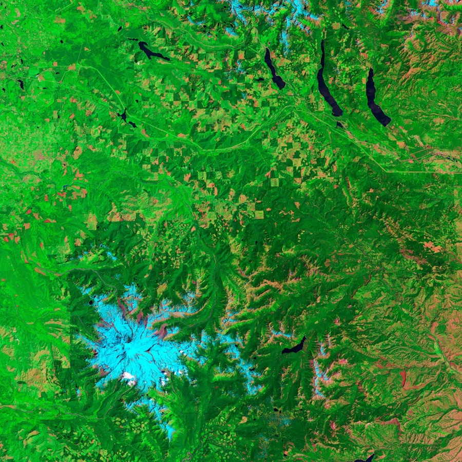
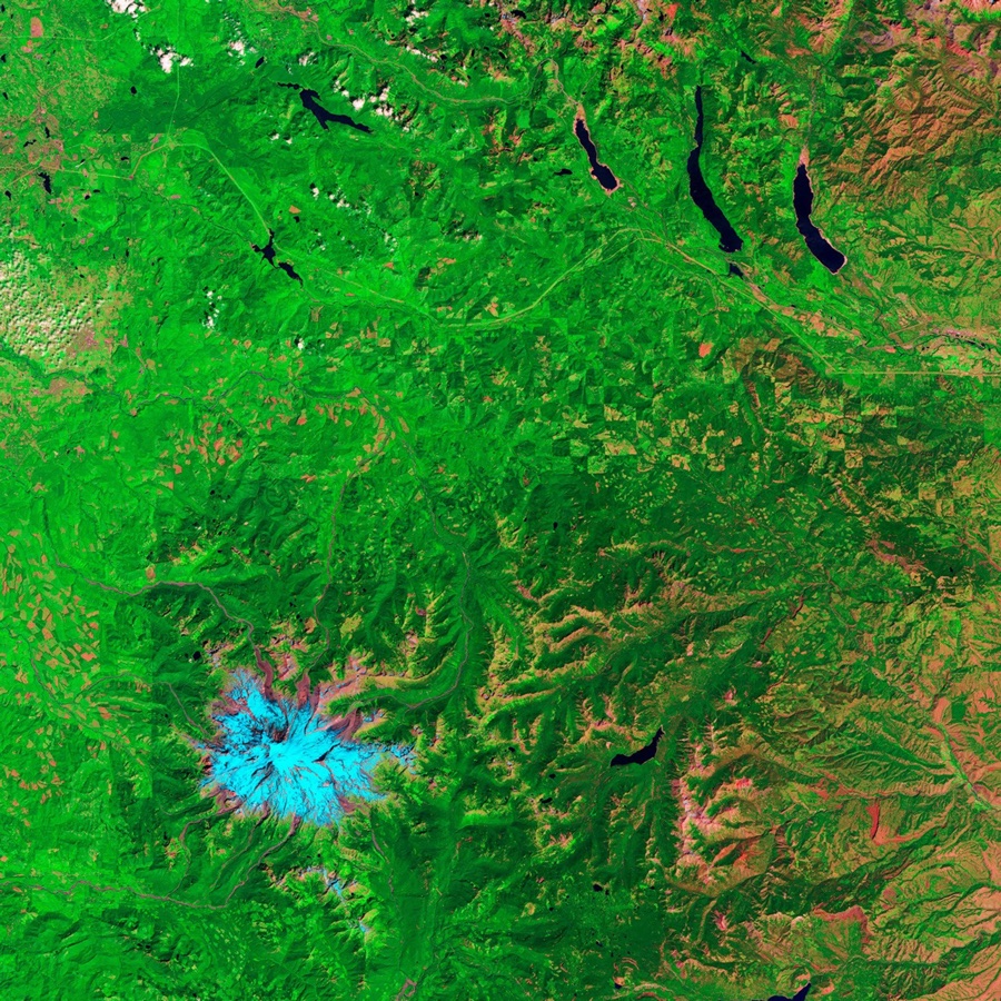
Here is what returning to the same forest can give us. These two Landsat 5 images show the same hills in Washington State, twenty-six years apart.10
Returning to a Washington forest
July 19, 1984
August 12, 2010
How much Earth fits in view?
A ground track gives us a line, though a satellite can see out to either side of it. How far? Picture a straight line from the satellite just grazing Earth's surface. That's the horizon. Anything farther around the curve is hidden by Earth itself.
From 400 kilometres up, only about 3% of Earth's surface is in view at once. At our medium height it's about 38%, and at geostationary height about 42%. These are shares of the whole planet. The second set of bars leaves out places where the satellite would appear less than ten degrees above the horizon, where we're looking almost sideways towards it.
Geometric visibility as a fraction of the whole Earth
Low orbit / 400 km
Medium orbit / 20,200 km
Geostationary / 35,786 km
Landsat's camera records only a 185-kilometre strip of its possible view. That width is its swath. For our forest images, we'd need to know when the strip next crosses the forest, as well as the time of day when it gets there. The forest might be within the satellite's horizon on an earlier pass and still be outside the picture.
How the orbital models and figures were madeThe clocks behind the paths, why maps split at their edges, and where the horizon sets a limit.
The model calculates nine trajectories, each sampled 1,441 times across one sidereal day, including both endpoints. Their starting positions are chosen for comparison.
The model uses an Earth sphere with equatorial radius 6,378.137 km, gravitational parameter 398,600 km³/s², a sidereal rotation of 86,164.2 seconds and a tropical year of 365.242 days, from NASA's Earth Fact Sheet. For circular orbits, radius is measured from Earth's centre, not its surface: a = R + h, v = sqrt(mu / a) and T = 2 pi sqrt(a³ / mu). The geostationary radius is derived from the sidereal period. The eccentric case solves Kepler's equation before rotating the position into Earth's frame.
The animation uses one real second for thirty simulated minutes. Earth and orbit radii are proportional within each panel, with separate zoom levels for the three heights. Each dot moves at a constant angular rate computed from its period; the Earth spokes share the sidereal period. All start six hours into the model and continue on the same clock.
Ground tracks use equirectangular maps, with breaks where a path crosses the antimeridian or a pole. The synchronous panels share a view from 40 degrees west to 40 east and 36 degrees south to 36 north, with the same display scale for latitude and longitude. Orbital latitudes are geocentric, measured from Earth's centre. Equal rectangles on these maps do not represent equal surface areas.
The land outlines in the global ground-track figure come from Natural Earth's public-domain 1:110 million polygons, reused from the Flight Paths & Great Circles map and projected onto the same axes as the ground tracks. Made with Natural Earth.11 The highlighted ISS-like passes use the retained samples from the first two orbital periods. Four arrowheads on the inclined synchronous track follow the direction between neighbouring samples.
The annual-orientation sketch shows a quarter-year change in the plane's direction, separate from a satellite's motion around Earth. It leaves out Earth's axial tilt and the slight eccentricity of Earth's solar orbit to isolate that change. The fixed and turning planes begin at the same arbitrary orientation; it is not a reconstruction of Landsat's crossing time. The ellipse comparison retains the same semimajor axis as the circular synchronous cases.
The Washington images are NASA Earth Observatory's published Landsat 5 composites from July 19, 1984 and August 12, 2010, resized together without changing their framing or colours. They illustrate repeat observation of forest change, rather than a controlled comparison of illumination.
The model omits drag, manoeuvres, other bodies' gravity, radiation pressure and Earth-shape force terms; actual spacecraft need orbit maintenance. Only the sun-synchronous example has a prescribed node rate, 360 / 365.242 degrees per solar day. This is a kinematic illustration, not an integration of Earth's J2 gravity term or a calibrated Landsat trajectory. Mission-like dimensions are nominal inputs, not estimates of current spacecraft states.
Visibility uses spherical-cap geometry. For minimum elevation epsilon above a ground observer's local horizon, the Earth-centred cap angle is alpha = acos((R / (R + h)) cos(epsilon)) - epsilon. The fraction is (1 - cos(alpha)) / 2, dividing cap area by the entire sphere's 4 pi R². The figure uses the retained, unrounded fractions for its bar lengths. There is no terrain, refraction, instrument field of view, scan schedule, radio link, cloud or constellation calculation.
Data and model: Data Essays, using the agency sources below.
Sources
- NASA Science. Gravity & Mechanics
Gravity, free fall and orbital motion. The preceding chapter page explains Kepler's laws, including the link between semimajor axis and orbital period.
- NASA/NSSDCA, David R. Williams. Earth Fact Sheet
Radius, gravitational parameter and the sidereal and annual clocks used in the model.
- European Space Agency. Types of orbits
Orbit terminology and the conditions for geostationary motion.
- NOAA NESDIS. Geostationary Satellites
The weather-observation role of GOES.
- NASA Johnson Space Center, Cynthia A. Evans and Julie A. Robinson. ISS Orbit Tutorial
Inclination and the ground track over a rotating Earth.
- GPS.gov. Space Segment
Nominal altitude and constellation arrangement.
- NASA Earth Observatory. Catalog of Earth Satellite Orbits
Sun-synchronous lighting. The equatorial-bulge and precession mechanism is detailed in Michael Mesarch's
GDC Orbit Primer, p. 4
(NASA Goddard, 2018).
- NASA Science, Landsat program. Landsat 8
Mission table: orbital period, local crossing time, swath and sixteen-day repeat.
- NASA Earth Observatory. Logging and Regrowth in Washington State
Images by Robert Simmon, using Landsat data from the Landsat Project Science Office. Landsat is jointly managed by USGS and NASA. Acquisition dates: July 19, 1984 and August 12, 2010.
- Natural Earth. 1:110 million land polygons
Public-domain geographic context for the ground-track maps. Made with Natural Earth.